Showing posts with label metro. Show all posts

Wednesday, July 7, 2021

"I want to make Metro the first choice in transportation that people think about" - Metro CEO Stephanie Wiggins

At Metro's State of the Agency presentation, new CEO Stephanie Wiggins uttered some powerful words that gave me goosebumps.:

"I want to make Metro the first choice in transportation that people think about. In great cities around the world: London, Paris, New York, D.C., taking mass transit is normal and expected. In those cities, it's just what people do. In those cities, public transportation is their obvious choice. I want Angelenos to think that way."


This is a bold and powerful statement.  It's the vision of Los Angeles public transportation that I have always had -- where it is not seen as merely "welfare mobility for the poor who would surely buy cars if they could", but as a viable, primary, and environmentally sustainable means of transporting oneself everywhere one needs to go.  I want the mobility experience I had living in New York and London, right here in Southern California.  I don't expect everyone to make that choice, of course.  However, it should be an option that is thought of as "normal" and "reasonable" for a world class metropolitan County like Los Angeles.


More power to her.  She has my full support. 

Wiggins also mentions the importance of equity and compassion, and that law enforcement will not the first resort in dealing with homelessness.

I really appreciated her honest admission that the rollout of NextGen last week could have been better,:  "We have learned some tough lessons over the last week."  She promised more accountability, transparency, and clearer communications about fare collection and the NextGen rollout.

Also speaking on the program was incoming Metro Chair, Los Angeles County Supervisor Hilda Solis.

I encourage you to watch the whole program.  Wiggins begins her remarks at minute 34:


Wednesday, June 30, 2021

How Metro Can Do Better Next Time

This is not a bash Metro post.  I believe in Metro's mission, want Metro to succeed, and for Los Angeles County to have a world class transit system on the level of New York, London, Paris, and Tokyo.

But let's be honest.  Metro's rollout of its Service Changes on June 27, 2021, and its NextGen Service plan, was poorly executed.  Metro's new CEO Stephanie Wiggins admitted as much in a note on fares, enforcement, and service changes.  It is welcome to see Metro publicly acknowledge there was a problem.

Kenny Uong, who is quickly making a name for himself in Southern California for his transit advocacy and enthusiasm blogged on Twitter his experience seeing confused riders all over the system, who had no idea that the service changes were happening or what they were, and bus stops still having old signage.  


As of writing this post, Metro still had old bus service maps from 2017-18 on its website, which is certainly not helpful for anyone trying to figure out how to navigate the current system today.  Not everyone riding Metro has a smart phone or can easily use an app like Transit or Google Maps. 

Metro had also issued a confusing "TAP where you can" statement, with bus operators quoting fares that riders were unprepared for paying.  


Fortunately, Metro provided clarity today.


What we should have been doing this week is celebrating Metro's more frequent service on certain lines and the rollout of the new bus lanes on Alvarado.  Unfortunately, this was all overshadowed for many riders, especially for those who depend on transit as their primary source of mobility. 

However, this can be a learning opportunity.  Here is how Metro can do better when rolling out service and fare changes in the future:

  • New systemwide maps should have been designed and publicly released prior to enacting service changes. People need to see how the system works as a whole. More frequent service should be colored differently than less frequent service. Create an "owl service" map too.  San Francisco MUNI posts current service maps at all of its bus shelters.  Why can't Metro do this as well?  (This is also free publicity as pedestrians walk past the maps and can see all of the places that the bus system goes.)


  • Bus stop signage should be changed prior to enacting service changes, with flyers warning about the start date at all affected bus stops.  As Alissa Walker tweeted, "If this was a freeway the signage would have been replaced overnight."

  • Metro needs clarity on fares and to issue advance notice of fare changes. Either we have them or we don't. Metro can opt not to enforce fare collection, but be clear about the policy.  As Metro buses can broadcast messages like, "Service changes begin ______", or "Masks are required", or "Go Dodgers!", buses could also broadcast messages like "Fares to resume on ______".
    Also, for convenience, TAP readers should be posted on the left of the front entrance of every bus to speed the boarding process for everyone.

In short, have everything in place for the ridership BEFORE enacting service changes or fare increases.

It is truly wonderful that Metro is expanding rail service throughout the County which has my full support.  Now let's also give its bus system the upgrade its ridership deserves, like transit lanes on all major corridors.  


Friday, May 28, 2021

Another Way to Provide Bus Rapid Transit to Cal State Northridge

Metro Los Angeles is currently studying a bus rapid transit (BRT) line for the North San Fernando Valley.  Here is what the current alternatives look like.


However, all is not well with this project.  Acccording to Numble on Twitter, Metro is considering caving into NIMBYs on this project.


This would be disastrous for transit riders in this area.  In particular, this would leave California State University, Northridge (CSUN) out of our growing mass transit system.  If this terrible-case scenario occurs, I've been thinking about how else to serve CSUN.

One idea that has long been discussed is to have branch services from the "Orange" Line (now the "G" Line) on other busy north-south corridors in the San Fernando Valley.  One of these proposed busy corridors is Reseda Blvd.  

My proposal would be to have a branch service of the G-Line going north-south on Reseda, east-west on Nordhoff, and CSUN along White Oak as seen below.  We'd have G1 service between North Hollywood Metrorail station and Chatsworth Metrolink/Amtrak Station, and G2 service between North Hollywood Metrorail station and CSUN.


But we can see from this map even though we would still serve CSUN, what a large east-west gap in mass transit we are leaving out of our system in the North San Fernando Valley.  I really hope NIMBYs do not prevail here.  We need BOTH the proposed North San Fernando Valley BRT and a Reseda Blvd. BRT.


Also, coming to the San Fernando Valley will be a "Sepulveda" Line (hopefully as heavy rail and not monorail) between the Valley and the Westside, as well as a planned BRT route connecting North Hollywood to Burbank, Glendale, and Pasadena.

A note for the future.  Eventually, the G-Line may be upgraded to light-rail.  A further enhancement I would support for this new Reseda Blvd. BRT is to run it between Universal City station and CSUN via Ventura Blvd.  Somehow Ventura Blvd. keeps getting left out of our San Fernando Valley mass transit conversation, when we should already be installing bus lanes on it.


And, of course, we should be doubletracking and upgrading the Metrolink/Amtrak rail corridors as well.

What do you think?

Thursday, May 27, 2021

Link the coming Sunset and La Cienega Bus Rapid Transit Corridors

 Here is a Metro Los Angeles map of potential transit corridors for possible upgrade to Bus Rapid Transit.   


Metro  recently released it's top five priorities for Bus Rapid Transit corridors.


The La Cienega BRT Line would run from Slauson to Santa Monica Blvd.  Why not link this BRT Line  to the new proposed Sunset - Cesar Chavez BRT Line via Santa Monica Blvd. and/or Sunset Blvd.?


That map may off on scale, but a BRT Line between the ocean - Venice - La Cienega - San Vicente - Santa Monica - Sunset - Cesar Chavez - Union Station sounds pretty cool, doesn't it?  Actually that alignment works really well as a streetcar/tram too.

(As a side note, La Brea is also targeted for future BRT.  Well, if La Brea is already getting BRT, then surely the Crenshaw Metrorail Northern Extension project should flow at least as westerly as Fairfax.  La Brea doesn't need both, especially when we compare a potential stop to serve The Grove / Television City at Beverly & Fairfax, versus the two gas stations and a car rental at Beverly & La Brea.)


Wednesday, July 22, 2020

Revisions to Metro's NextGen Bus Plan

Here is the good news.  After community outreach, Metro has made some revisions to its NextGen Bus Plan, and Line 218 has been saved, albeit in truncated form between Ventura Blvd. and Santa Monica Blvd.  Personally, I'd extend it from the Orange Line to Wilshire Blvd. (Purple Line), but I am grateful to see it survive it at all.


To review, the NextGen Bus Plan essentially takes the Rapid and Limited bus lines and combines them with their respective Local bus lines to create a more frequent overall service.  This approach has worked in improving ridership in other regions.  Here are the lines most relevant to West Hollywood:

Rapid 704 and Local 4 are combined into new frequent Line 4


Limited 302 and Locals 2 and 200 are combined to form frequent Line 2.


Rapid 705 is combined with Local 105 into new frequent Line 105.


Limited 312 is combined with Local 212 to create new frequent Line 212.


The change I find most fascinating is the merging of Rapid 780 with Locals 217, 180, and 181 into one new powerhouse frequent Line 180.


"In my opinion, this new frequent Line 180 is really going to need bus lanes on Hollywood Blvd. between La Brea and Vermont to work operationally."  Hollywood Blvd. is being considered for a makeover anyway, so now is the time.  So many bus lines start and finish on Hollywood, coming and going from all directions, that bus lanes on it make practical sense to me.

Here is one for my friends in Malibu.  Line 534 turns into Line 134 and has more frequent service.


I look forward to seeing the NextGen Bus Plan put into operation so that we can enjoy a more frequent service.  I've shown the major plans affecting West Hollywood, but you can see all of the NextGen Plan Updates by clicking here.

Monday, January 13, 2020

How Metro's Proposed Frequent Bus "NextGen Transit First Service Plan" Could Affect West Hollywood

Metro is undergoing a redesign of its bus network called the NextGen Bus Study.  After a series of community meetings, a draft frequency-enhanced "Transit First Service Plan" has been released.


The basic strategy as I understand it is to fold all but three rapid lines into corresponding local service, but increase the stop spacing on these new combined lines to create a core network where "83% of Metro's riders" will be walking distance from a bus that has 5, 7, or 10 minute frequency all day.  This sort of transformation to bus service has proven successful in other regions.


There are tradeoffs to any overhaul of course.  Metro is trading losing speed on individual rapid trips for the gain of frequency of service on many lines.  However, when one includes the time spent waiting for a bus as part of overall travel time, this may be a trade off that balances out for many people.  Check out all of the proposed changes by clicking here.


Here is how West Hollywood is likely to affected by the bus service changes according to the draft:

Santa Monica Blvd:  The Rapid 704 would fold into the a more frequent Local 4, with unproductive stops removed.  (Note: this may end West Hollywood's one-seat ride to Union Station.)

Sunset Blvd:  The Limited 302 would fold into the Local 2, with unproductive stops removed.  At Alvarado, the 2 would run north-south.  (Note: this would create a one-seat ride between UCLA and USC.)

Fairfax Avenue:  The Rapid 780 would be combined with the Local 180 and Local 217, for one new 180 line that runs from Pasadena City College to Hollywood Blvd., and then down Fairfax to the La Cienega "E (Expo) Line" Station.

La Cienega Blvd:   The Rapid 705 would fold into the Local 105, with unproductive stops removed.

San VicenteLine 30 would no longer run up San Vicente to West Hollywood, but Line 14 would.

La BreaThe Limited 312 would be folded into the Local 212, with unproductive stops removed.

Crescent Heights:  Once proposed change I do not agree with is the elimination of Line 218 which currently runs over-the-hill between Laurel Canyon & Ventura Blvd. and Cedar Sinai Hospital via Laurel Canyon, Crescent Heights, Fairfax, and 3rd Street.  Elimination of this service would require new time consuming forced transfers for current Line 218 passengers on both sides of the mountain.  I suggest that Metro try redesigning the service first.  One proposal would cut out the 3rd Street portion, but extend the line north to the Orange Line, and run Line 218 between the Laurel Canyon Orange Line Station and The Grove, and see if feeding to/from the Orange Line improves overall performance.  Another possibility would be to extend the 230 south over the hill to Santa Monica Blvd.  I hope Metro considers these alternatives before scrapping a valuable, direct over-the-hill service entirely.


One thing that will be needed to make this bus network overhaul work:  BUS LANES!  Southern California needs a comprehensive network of color-painted and enforced bus lanes to compliment our (thankfully) growing and expanding Metrorail and Metrolink networks.

There are another series of upcoming community workshops on this frequent "NextGen Transit First Service Plan" all over the County over the next several weeks, including one in West Hollywood, on Wednesday, February 12, 2020, 4 – 7 PM, at Plummer Park, 7377 Santa Monica Blvd., West Hollywood, CA 90046 (Accessible via Metro Lines 4/704; and Weho Cityline).

Click here to find an upcoming community workshop near you.  You may send in your comments and suggestions about this plan to Metro at nextgen@metro.net. 


Thursday, October 10, 2019

Why I like the "Hybrid" Option for the Crenshaw Northern Extension Project

As we get closer to Metro selecting a "Locally Preferred Alternative" for the 
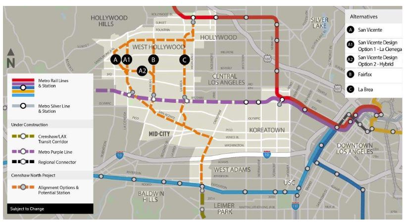
Crenshaw Northern Extension Project, a new round of community meetings is about to take place.  On the menu for discussion will be a new "hybrid" option (seen below).


The more I study the "hybrid" alignment (A2 plus A/A1 above) for the Crenshaw Northern Extension Project the more I like it. At first the geometry of the line threw me, but this option hits all the major job/entertainment/retail generators north of Wilshire.


Going to where people actually want to go is what will make this line the tremendous success it is destined to be.  People don't just travel through this area, they travel TO this area and within this area.

Let's just remember why we need this line.  It intersects so many other Metro lines (Green, Expo, Purple, Red) and major bus corridors (Santa Monica, La Cienega, Fairfax,,etc.) that it will increase ridership on the whole system.  Plus, this extension will vastly increase mobility for disadvantaged communities with direct connections to job and entertainment centers like Cedars-Sinai, Beverly Center, The Grove, and West Hollywood.

There is a minority of people out there that prefer La Brea for this alignment. They look at La Brea on the map, see a "straighter" line, and say, "We want speed, speed, speed!  They don't seem to care about direct access to any of the ridership generators between Wilshire Blvd. and Hollywood Blvd. further west (like Cedar Sinai, the Beverly Center, the Grove, West Hollywood, etc.).  This is why I do not agree with them:

As a daily user of the transit system I think to myself, "If the options are: (A) riding a few more minutes underground to go directly to the location I actually want to go (West Hollywood, Cedar Sinai, Beverly Center, The Grove, etc.), or, (B) getting off the train at La Brea and THEN waiting above ground to transfer to a bus and THEN riding through heavy surface traffic to finally get where I actually want to go, well (B) really does not seem like the "speed" option after all, does it?

I'm sure a nurse riding from Leimert Park to her job at Cedar Sinai would rather take a quick one-seat ride underground rather than ride to Beverly/LaBrea, wait for a bus at LaBrea for however long, and then ride stop and go in heavy traffic to finally get to her job.  When you conceive the whole trip, the notion of the "speediest" option changes.

I say build this line and put the alignment directly stopping where people actually want to go.  And make its northern terminus at the Hollywood Bowl to help relieve nighttime Hollywood Bowl traffic there.

I believe the few extra minutes of curves required to make these stops, which no one will notice or care about underground, will still be MUCH quicker than sitting in heavy surface traffic above ground, and will not at all be a deterrent to its success.

I also reject talk of breaking this project up separately into “two-lines” as there is only going to be one line built in this area for decades.  By the time all of the current Measure R and Measure M projects are finished it will be decades for a second line is even proposed.  So don't be fooled or distracted by those people advocating a  so-called "speed" line on La Brea today while leaving second "access" line to be proposed and built at some vague date decades later (or never).

There are also those who will wonder, "what about the people traveling from the San Fernando Valley to LAX?"  Good question! I think most of them will likely use the coming Sepulveda Transit Corridor Project (seen below), but will still find this hybrid underground alignment MUCH quicker than sitting in surface traffic.


The next round of Metro Community Meetings for this project are soon.

Tuesday, October 22, 2019, 6 – 8 p.m.
Plummer Park, 7377 Santa Monica Blvd. West Hollywood, CA 90046.
Accessible via: West Hollywood Cityline and Metro bus lines 2, 4, 212, and 704.

Thursday, October 24, 2019, 6 - 8 p.m.
Wilshire Crest Elementary School, 5241 W. Olympic Blvd. Los Angeles, CA 90036.
Accessible via: Metro bus lines 20, 28, 212, 312, 720 and 728.

Saturday, October 26, 2019, 10 a.m.  – 12 p.m.
Virginia Road Elementary School, 2925 Virginia Road, Los Angeles, CA 90016.
Accessible via: DASH, Metro Bus lines 37, 38, 210, 710 and 740.

Tuesday, October 29, 2019, 6 – 8 p.m.
Rosewood Avenue Elementary School, 503 N. Croft Ave. Los Angeles, CA 90048.
Accessible via: DASH, West Hollywood Cityline and Metro bus lines 10, 14, 105 and 705

I will see you there!  You can also submit your feedback about this line to crenshawnorth@metro.net.

Although I very proudly sit on the City of West Hollywood's Transportation Commission, this blog post is my own opinion.  I am not claiming to speak for the Commission, the City Council, or our hardworking city staff.  

Thursday, July 25, 2019

What is Metro's NextGen Bus Study's Regional Service Concept

Metro has set out to design a new bus network that is more relevant, reflective of, and attractive to the residents of LA County, which it has branded as the NextGen Bus Study. This type of overhaul and updating of the bus system happens about every few decades. It's important to keep the bus network relevant and upgraded to represent current demand and travel patters.  Hopefully this will help with increasing Metro bus ridership as a similar redesign recently helped ridership in Austin, Texas.

Metro has completed Phase 1, its "Research and Analysis" phase.  Based on the data collected and a vast amount of outreach, Phase 2 is now presentation of Metro's "Regional Service Concept".  Phase 3, after the approval of the "Regional Service Concept", will be development of the "NextGen Service Plan", expected in early 2020. Phase 4 will be "Implementation" of the plan once approved.

So what is this Regional Service Concept that Metro is proposing to base design of its new service plan?

According to Metro, "Together with your comments, the Regional Service Concept is guiding the NextGen bus service planners as they examine every Metro bus line and bus stop to determine the best system redesign possible."  This phase will defines the goals and objectives of the new bus network, and will include measurements of for success of the new network, route and network design concepts based on public input and data analysis, a framework for balancing the inevitable tradeoffs that this new plan will require, and, of course, Metro’s Equity Platform considerations.

In 2018, the Board adopted Metro Vision 2028 as the agency’s strategic plan. Metro sees the NextGen Bus Study as addressing one of the plan's top goals: "Provide high quality mobility options that enable people to spend less time traveling."

The Concept lists three key factors to developing the new transit network:
  1.  Transit Propensity - Identity the areas where the propensity to use transit is the greatest, by examining the market segments of transit customers (transit reliant riders, commuters, and discretionary riders) and the intensity of demand by population and place (prospective ridership generators);
  2.  Existing Service Performance -  identify and optimize the most productive segments of the existing bus network which matches current transit demand (what's already working well);
  3.  Service Environment - Removing land use barriers to successful service, and implementing transit supportive infrastructure (such as transit-only lanes).
In particular, check out "Attachment E" (pages 151-157) of the Concept for signs of what bus lines Metro scores as performing well in the current network, and what lines it scores as underperforming.

I expect people will be very interested about any proposed changes to their current transit lines, for many people their transit access and reliability can determine their mobility, their economic prosperity, and social/cultural opportunity.

It will be months before we see the new proposed NextGen Service Plan.  While we are waiting, check out the NextGen Bus Study Data Center where Metro has granted access to an amazing ocean of transit data analysis, more than enough to keep any transit fan occupied until the NextGen Service Plan comes out by early 2020.

For a Ridership Data Tool that "allows you to explore monthly ridership stats, line level trends, and historical information for every line in Metro's system," please click here.

For a Trip Density Per Census Tract Map that displays volumes of daily trip origins per census tract, including both transit trips (recorded by TAP data) and overall trips (car, transit, etc.), please click here and zoom in/out.

For a Corridor Segment Performance Map that "displays which segments have the most ridership and are the most productive," please click here and zoom in/out.

For a Frequency Map that "displays how often buses are arriving at stops for segments of each route, with the red lines showing they most frequent segments," please click here and zoom in/out.

For a Trip Length Distribution Map that "displays how far riders typically travel along the corridor based on their starting point, with darker red dots indicating longer trip lengths," please click here and zoom in/out to click on a starting point to display the average length.

For an Origin-Destination Patterns Sliding Map that "displays the pattern of where current transit riders are starting and ending their trips," please click here and zoom in/out and slide back and forth to compare origins versus destinations.

For a Seated Capacity Map that "displays how full, on average, the buses are on segments of each route. The darker the color represents segments of a route where buses are fuller". please click here and zoom in/out..

For a Stop Level Ridership Map that "displays the level of activity at each of Metro’s bus stops, with the red dots representing high activity, with detailed information on the number of boardings, on and off, by simply clicking each dot/stop," please click here and zoom/in out.

For a Transit Propensity Map that "shows you the areas where the propensity to use transit is the greatest," please click here and add the layers of demand data you want while zooming in/out.

Phew!  That is a lot of data.  I cannot wait to see the new proposed service plan.

Wednesday, July 24, 2019

Please Give Us Shade... (No, Really.)

Last night I was waiting for a bus at Wilshire Blvd. and 26th Street at a major bus stop that serves local and rapid buses, and here is what I saw:


Notice something interesting?  Here is another view.


People are not sitting in the hot sun in the pretty, artistic seating.  They are standing in the shadows of poles and trees.  This is how too many people wait for the bus in Southern California.  If you are a big and tall guy like me, the pole may not be big enough.


My question is. why isn't there a bus shelter?  Why isn't there shade?  It makes for a very uncomfortable wait.  When it rains, and we know from this year that it actually does rain in Southern California, we basically get wet.

Here is an example of a London bus shelter design  I love -- that has shade, seating, a map, a digital screen, and is ADA compliant -- that I would like to see all through Southern California.


Isn't this pretty?  Why don't we have adequate bus shelters throughout much of Southern California?   Don't blame Metro for this.  The quality (or lack thereof) of bus shelters and bus stops is largely the responsibility of  the cities in which they are located.

Also, are bus stops designed based on how aesthetically pleasing they look or for the benefit of the transit user?  Ideally both, but functionality is essential.

By pointing out this stop, I am not ragging on the transit-supportive city of Santa Monica here, or its terrific Big Blue Bus system.  This one stop is just an indicator of a county-wide deficiency.  I should also add that my city of West Hollywood is currently upgrading its bus stops and shelters, which is terrific.  But, if you don't have adequate bus stop shade where you live, work, and play, then go to your city's Transportation Commission meeting, or even its City Council meeting, and insist on quality bus shelters that offer real shade from the sun and rain during public comment. 

As I stated in my last blog, there are two basic views of public transit and its components that I run across:

(A)  "Public transit is method of moving masses of people of all classes and demographics conveniently from place to place, increasing mobility, cultural opportunity, and economic prosperity, while helping the environment and quality of life for all by providing an reliable alternative for people who would otherwise exacerbate traffic problems by driving more cars on our already clogged roads."

(B)  "Public transit is a form of "transportation welfare" meant to provide a subsistence level of mobility to poor people who would, of course, get their own automobile as soon as they have the means and opportunity."

Too many people think of transit in Southern California solely as (B) and therefore don't see the problem here.  If you only think of transit as just transportation welfare for poor people who would rather be driving a car, then you probably don't care about investing in or improving the system, or the experience of the transit rider. 

Having lived in New York, and other Metropolitan cities, I envision transit as (A), and that is why I seek to improve it for everyone in the Southern California region, because I see everyone as a potential user.  I absolutely reject the limited, outdated idea that "this is Southern California and we have a car culture, so mass transit will never work here."  Millions of people already use the system we have and voters passed Measures R (2008) and M (2016) to improve and expand our system.

One person has told me dismissively, "if we build transit shelters, the homeless will simply camp out in them".  Not if we adequately address the issue of homelessness, which is a whole other blog topic.  I also reject the idea that the severe issue of homelessness in Southern California should limit or be dumped on our transit system and its components.  Let's solve BOTH issues.

I don't write this blog post to complain.  I truly believe in mass transit as a public good, and a public good right here in Southern California.  If there is an amazing bus shelter in London, we here deserve no less.  If there is any amazing transit feature (signage, maps, technology) in any other city around the world, Los Angeles County deserves it too.  This a world class metropolitan capital of culture and commerce and we should have a transit system that is top of the line, and in the front of innovation -- not as an afterthought because, of course, we'd all rather be driving an automobile.  Let's have a world class transit system for everyone worthy of a City and County of Angels.

In order to have the robust, user-friendly rail and bus transit system we all want, please give sunny (and sometimes rainy) Southern California adequate shade at all its transit stops.

-----

Edited to Add:  Please read this excellent Places Journal essay on "Shade", which explains who in Southern California gets shade (and who doesn't) and why.  Please click here to read.

Monday, July 22, 2019

Homelessness and Public Transit in Southern California -- What is the answer?

Homelessness is not only a housing issue, but a public transportation issue too. Here is shiny new bus stop seating right across the street from West Hollywood City Hall that no paying or prospective transit passenger on their morning commute can use because it has been taken over by a sleeping homeless person.


Other scenarios people who use transit are all too familiar with:
- A homeless person takes up multiple seats with their belongings forcing other people to stand.
- A homeless person either under the influence of alcohol/drugs and/or is mentally ill is disruptive and threatening to other passengers.
- A homeless person who hasn't bathed in several days makes for an unpleasant ride for everyone else around him on the bus.

This post is not meant to be a general complaint about "the homeless".  I have tremendous compassion for homeless people.  We are speaking of  flesh and blood human beings here who deserve our consideration and respect and help.

However, allowing homeless people to take over public transit infrastructure hardly seems fair to the paying transit passengers who deserve safe, clean, comfortable rides.  (If you are someone who drives a single-occupancy automobile thinking, "Well, what's the problem?  I'd stand for a homeless person,"  I'd ask you in return, "how often do you have to?"  It's easy to invoke someone else's inconvenience in the name of one's own compassion.)

When increased homelessness spills onto the transit system and its infrastructure, it suppresses transit ridership because it makes the journey less comfortable and for some people less safe.  So then some people who can afford to opt out of the system, do.  I don't have any raw numbers, but I certainly have an endless supply of anecdotal evidence from people who tell me this is one of the reasons they personally avoid using transit or have stopped using transit.

There are two basic visions of public transit I come across:

(A)  "Public transit is method of moving masses of people of all classes and demographics conveniently from place to place, increasing mobility, cultural opportunity, and economic prosperity, while helping the environment and quality of life for all by providing an reliable alternative for people who would otherwise exacerbate traffic problems by driving more cars on our already clogged roads."

(B)  "Public transit is a form of "transportation welfare" meant to provide a subsistence level of mobility to poor people who would, of course, get their own automobile as soon as they have the means and opportunity."

Too many people think of transit in Southern California solely as (B) and therefore don't see the problem here.  Having lived in New York, and other cities, I envision transit as (A), and that is why I seek to improve it for everyone in the Southern California region, because I see everyone as a potential user.

However, it is increasingly clear to me that unless we do a better job of addressing the issue of homelessness in Southern California, our best efforts to improve transit here are going to be inhibited.  In essence, those of us who are transit advocates need to become homelessness advocates out of necessity.

What is the scale of the homelessness problem in Los Angeles?  The Los Angeles Homeless Services Authority (LAHSA) estimated 59,000 people on the streets of Los Angeles County.  That is truly a heartbreaking number.

So how can we solve this?  The City of West Hollywood addresses homelessness with a multi-disciplinary, multi-agency, collaborative response.   The City also has a five year plan to address homelessness.

However, no one city or one community can solve the issue of homelessness for the whole region.  All of us in Southern California need to do our part, and every community in Los Angeles County needs to do its part too.

In March 2017, Los Angeles County voters passed Measure H to raise money to address the issue of homelessness.  Los Angeles County also has 47 Strategies to Address Homelessness.

What do you think?   Constructive and compassionate solutions welcome.

-----

Edited to add:  A Social Services Manager from the City of West Hollywood has informed me that if we see a homeless community member in West Hollywood who we would like to help, please call WeHo’s homeless concern line at 323-848-6590. They will meet the homeless community member where they are at and offer services to help get them off the street. 

Metro Los Angeles has a homeless task force.  An article about how Metro is expanding its homeless services appeared in the Santa Monica Daily Press on June 1, 2019.  Please click here to read it.